
Just several days after Hurricane Ida’s category four landfall in Louisiana, it’s remnants slammed the Northeast as one of the most devastating storm systems the region has ever seen. The states of New York, New Jersey, Pennsylvania, and Connecticut bore witness to heavy downpour and flash flooding which amounted to power failure, infrastructure damage, and an ongoing rise in death toll as first responders continue their search and rescue for the missing in the most affected communities.
According to the National Oceanic and Atmospheric Administration’s National Hurricane Center (NHC), within a 24-hour period, Ida found itself with increased sustained wind speeds by at least 35 miles per hour, classifying it as a “rapidly intensifying storm.” Northeast state and local officials were left stunned by Ida’s escalation in power and are now vowing to make changes to prepare for a new normal as the implications of climate change have become ever more present in weather patterns.
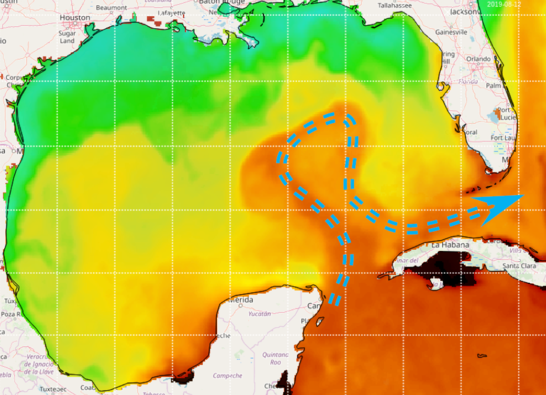
But how exactly did climate change factor into Ida’s unusual intensity up north? To answer this question we can examine the storm’s origin and tracked path as it made its way towards the Gulf Coast.
Ida developed into a category two hurricane in the Caribbean Sea on August 28 and was expected to strengthen as it passed over a pool of warm, deep water, called an eddy, that had formed over the eastern part of the Gulf of Mexico. This eddy is associated with a warm ocean current called the Loop Current that flows northwards between Cuba and the Yucatan Peninsula, into the Gulf of Mexico, and back southeast through the Florida Straits. The storm was able to tap into this incredible reservoir of energy. The continued heat and moisture permitted drops in central pressures which fueled intense winds and condensation.
Loop Current; Photo courtesy of NOAA/AOML OceanViewer

Global warming has done no better at reducing the extremities of this type of weather. The Environmental Protection Agency (EPA) has indicated a 90% excess in heat absorption by our Earth’s oceans since 1955. This has since worsened as humans continue emission of greenhouse gasses. Warmer waters are more likely to evaporate into the atmosphere, implying the formation of heavy precipitation events such as Hurricane Ida.
At its worst, the extratropical storm dumped 10 inches of rain in a single night over cities like Newark and Manhattan. Hoboken itself was inundated with a record breaking rainfall total of 4.92 inches. The following day, flood waters were still present as recovery efforts began and the city was placed under a “Boil Water Advisory” by the New Jersey Department of Environmental Protection. Despite the city’s pre-existing coastal flood mitigation projects that had been well underway after Sandy, much of Hoboken’s central and southwest areas still found themselves susceptible to torrential downpour and flooding.
At a press conference, Hoboken Mayor Ravi Bhalla pointed a finger towards “the fossil fuel industry, big oil and its enablers” as “the culprits,” wreaking havoc on “quality of life here in Hoboken, throughout the region and other parts of this country.” He insisted that ongoing projects to mitigate flood risks across the city will continue, such as the construction of the North and Southwest Resiliency Parks which have hopes of detaining 200,000 gallons of stormwater runoff through the use of green infrastructure.
When these projects will reach their completion date is unclear, but in the meantime, efforts must not delay to prepare communities for the onset of a persistent hurricane season.
Be First to Comment